


The Bergslagsleden trail in central Sweden offers an exceptional long-distance hiking experience away from the crowds. This 280-kilometer trail winds through scenic forests and shimmering lakes, rich with cultural history. What’s more, whether you’re planning a multi-week thru-hike or a simple weekend getaway, this guide covers everything you need to know, from trail highlights and practical tips to a detailed stage-by-stage itinerary.
If you’re looking for an unforgettable long-distance hiking adventure in Sweden, the Bergslagsleden trail should be at the top of your list. Stretching 280 kilometers through the scenic landscapes of Bergslagen in central Sweden, this trail combines deep forests, shimmering lakes, cultural history, and peaceful solitude. Whether you want a multi-day trek or just a weekend section hike, Bergslagsleden offers something for every outdoor enthusiast.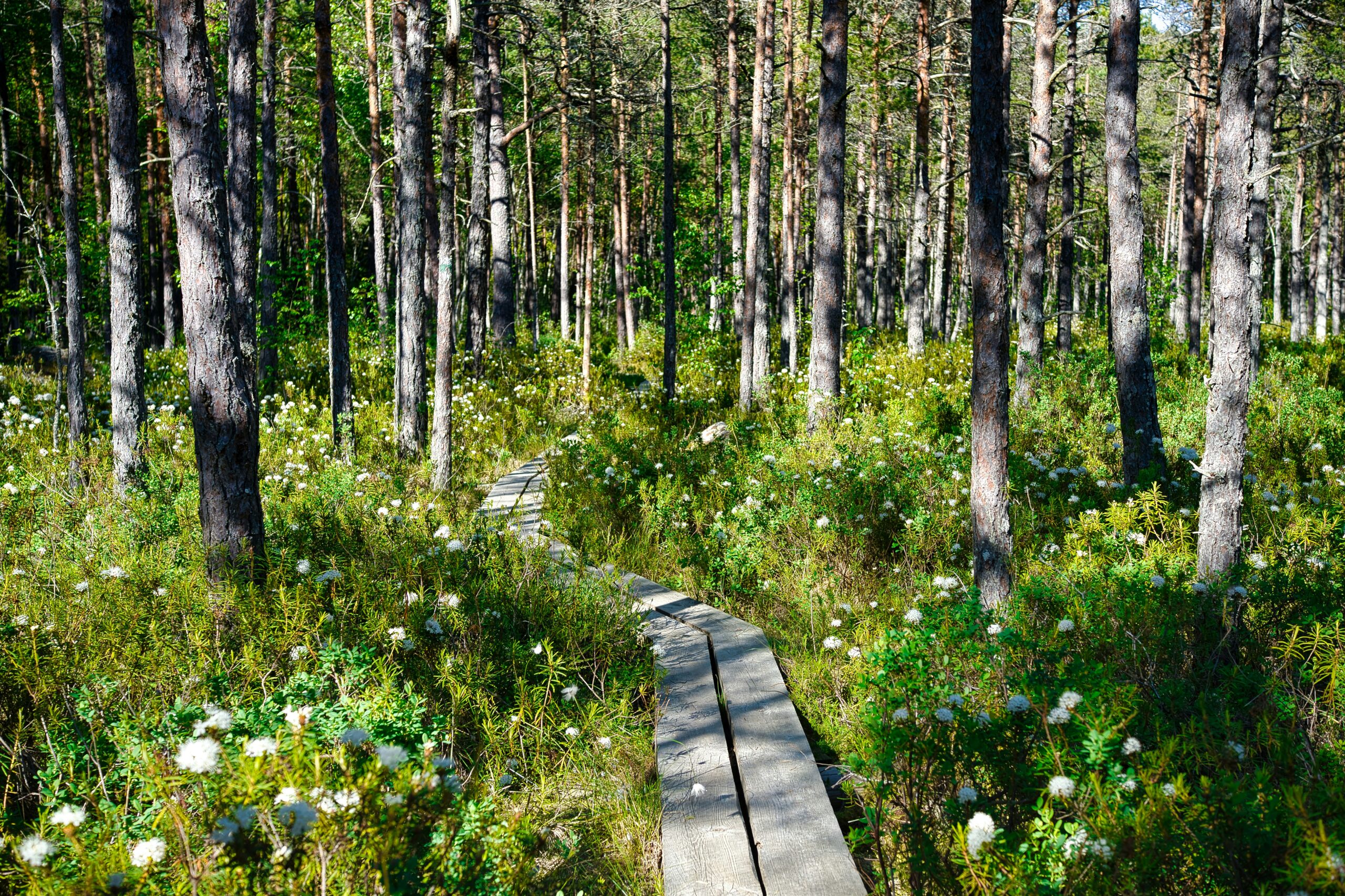
Contents
What is the Bergslagsleden Trail?
The Bergslagsleden is one of Sweden’s classic long-distance hiking trails, running from Kloten in the north to Stenkällegården in the south. It winds through Örebro County and passes national parks, nature reserves, mining heritage sites, and countless lakes perfect for wild swimming.
- Length: 280 km
- Sections: 17 marked stages (10–20 km each)
- Trail color: Orange markings
- Difficulty: Moderate – mostly forest and lake terrain, with some rocky sections and rolling hills
Highlights of the Bergslagsleden Trail
- Vast Forests and SilenceBergslagen is known for its wilderness. In fact, you can expect to walk for hours without meeting another person, surrounded only by pine forests, moss carpets, and birdsong.
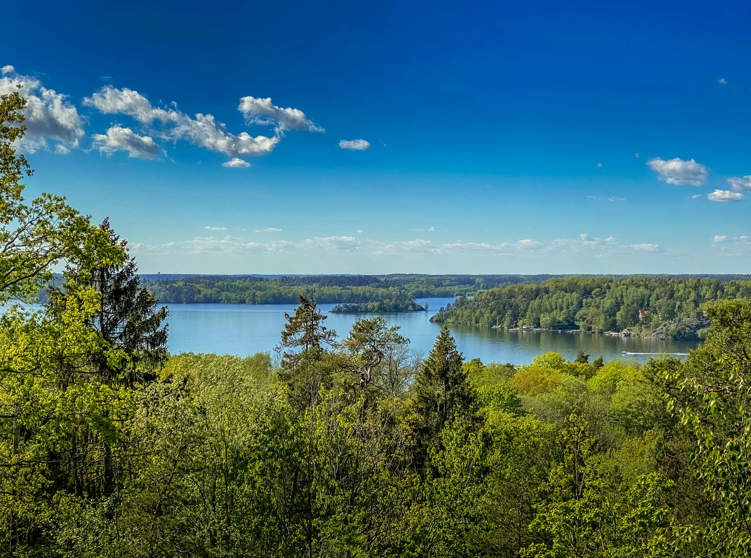
- Lakes EverywhereThe Bergslagsleden trail passes dozens of lakes where you can swim, fish, or just rest by the water’s edge. For example, some of the most beautiful include Stora Kloten, Norra Lången, and Multen.
- Cultural HistoryThis region was once the heart of Sweden’s iron industry. Along the way, you’ll also see old mine ruins, charcoal pits, and preserved mining villages. It’s a unique mix of nature and history.
- National Parks and Nature ReservesIn addition, the Bergslagsleden trail passes through Garphyttan National Park (one of Sweden’s oldest), and several reserves like Kilsbergen, offering varied landscapes and rich wildlife.
- Wildlife EncountersMoose, roe deer, beavers, and even lynx live in these forests. Beyond the large animals, birdwatchers can also spot owls, woodpeckers, and osprey.
Practical Information for Hiking the Bergslagsleden Trail
Sections & Planning
The trail is divided into 17 stages, each 10–20 km, making it easy to plan day hikes or longer treks. Many hikers choose to do it in 2–3 days sections or commit to the full trail in about 2–3 weeks.
Accommodation
- Shelters & windbreaks: Free, simple wooden shelters are available along the trail, usually near lakes.
- Camping: Furthermore, wild camping is allowed under Sweden’s Allemansrätten (Right of Public Access).
- Guesthouses & cabins: These are also available in some villages and near trailheads.
Best Time to Hike
- Late spring to early autumn (May–September) is ideal.
- Autumn (September–October) offers fewer mosquitoes and stunning colors.
- Winter hiking is possible but requires experience, as snow covers parts of the trail.
Getting There
- Northern trailhead (Kloten): Accessible by bus from Kopparberg or Lindesberg.
- Southern trailhead (Stenkällegården): Near Karlsborg, reachable by car or bus connections.
- Major cities nearby: Örebro (30–60 minutes away) and Stockholm (about 3 hours).
Suggested Itinerary
3-Day Short Hike
- Day 1: Kloten → Nyberget (through Kloten Nature Reserve, 18 km)
- Day 2: Nyberget → Måltorp (lakeside shelters, 15 km)
- Day 3: Måltorp → Kopparberg (historic mining area, 20 km)
Full Trail Thru-Hike
- Distance: 280 km
- Time: 14–20 days
- Tip: Resupply in towns like Kopparberg, Hällefors, and Laxå.
Why Hike the Bergslagsleden Trail?
Unlike more famous Swedish trails such as Kungsleden, the Bergslagsleden trail is less crowded, making it perfect if you want real wilderness and solitude. Nevertheless, this hiking trail is well-marked, easy to access, and offers a beautiful balance of Sweden’s natural and cultural heritage.
If you dream of camping by quiet lakes, hiking endless forest trails, and discovering hidden mining history, Bergslagsleden is one of the best hiking trails in Sweden for you.
Bergslagsleden Trail – Stage by Stage Guide
The Bergslagsleden trail is divided into 17 marked stages, each between 9–23 km long. You can hike them individually as day trips or link them together for a thru-hike. For clarity, we’ve broken the 17 stages into four key sections, with highlights for each:
Northern Bergslagsleden Trail Stages
- Stage 1: Kloten → Nyberget (~17 km)This peaceful opening stage leads you through the quiet pine forests of Kloten Nature Reserve. As you go, keep an eye out for the inviting lakeside shelters, which are perfect for a quick break or an overnight stay.
- Stage 2: Nyberget → Måltorp (~15 km)Next, the trail continues through a landscape of small lakes and wetlands on old forest paths. This section offers excellent opportunities to spot local wildlife like moose and beavers.
- Stage 3: Måltorp → Kopparberg (~20 km)This stage takes you through historic mining landscapes. You’ll pass by the ruins of old ironworks as you make your way into the small town of Kopparberg, which is a great place to resupply.
- Stage 4: Kopparberg → Gillersklack (~21 km)Get ready for a climb! This section includes an ascent up the 360-meter Gillersklack hill, where you’ll be rewarded with panoramic views. The area is also a popular ski destination in winter.
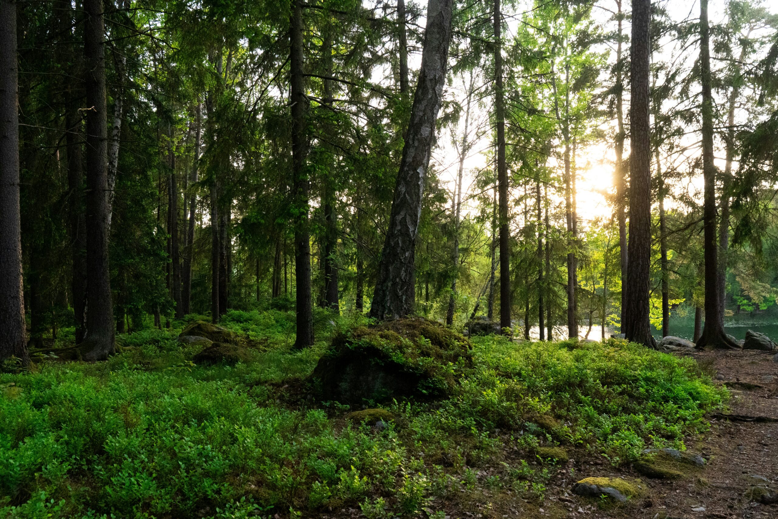
- Stage 5: Gillersklack → Gråmon (~17 km)To conclude this section, you’ll journey into classic Bergslagen wilderness. The trail here is characterized by dense spruce forests and quiet lakeside camping spots, offering a true sense of solitude.
Central Bergslagsleden Trail Stages
- Stage 6: Gråmon → Hällefors (~17 km)Continuing on, the path leads you into Hällefors, a good stop for food and supplies. The terrain features a mix of forests, lakes, and cultural sites.
- Stage 7: Hällefors → Lilla Mon (~13 km)A shorter stage with scenic lakeside paths, it’s perfect for a relaxing day. You’ll find simple shelters and great swimming spots if you hike in the summer.
- Stage 8: Lilla Mon → Nyttorp (~20 km)In contrast to the previous stages, this is a remote, quiet wilderness section with minimal civilization. Consequently, it is perfect for those seeking deep solitude and a chance to feel completely immersed in nature.
- Stage 9: Nyttorp → Sixtorp (~15 km)This stage is a major highlight of the trail, taking you through the Sixtorp Nature Reserve. Here, you’ll encounter rolling hills, wetlands, and well-maintained educational paths.
- Stage 10: Sixtorp → Mogetorp (~14 km)As you get closer to Örebro, the forest landscapes become more diverse. As a result, this section offers excellent opportunities for birdwatching as the habitat changes.
Kilsbergen Mountain Stages on the Bergslagsleden Trail
- Stage 11: Mogetorp → Blankhult (~17 km)Moving into the next section, you will enter the stunning Kilsbergen mountains. Here, you’ll hike along rocky ridges with dramatic views across the Bergslagen region.
- Stage 12: Blankhult → Suttarboda (~13 km)You’ll then enjoy more of Kilsbergen’s rugged scenery. This stage features deep forest paths and the ruins of old farms, blending nature with local history.
- Stage 13: Suttarboda → Ånnaboda (~10 km)Specifically, this short stage leads you to Ånnaboda, a popular outdoor center. You’ll find a lakeside café, cabins, and camping facilities, making it a great rest point.
- Stage 14: Ånnaboda → Leken (~18 km)The trail takes you through Garphyttan National Park, one of Sweden’s oldest. The park is renowned for its rich flora and diverse birdlife.
Final Bergslagsleden Trail Stretch to Tiveden
- Stage 15: Leken → Sixtorp (southern) (~23 km)First in this final stretch, this is the longest stage of the trail, taking you through dense wilderness. The remote nature of this section, therefore, increases your chances of spotting larger wildlife.
- Stage 16: Sixtorp (south) → Bosjön (~15 km)Enjoy the peaceful scenery around Lake Bosjön. This area is perfect for wild camping and swimming in the quiet forests.
- Stage 17: Bosjön → Stenkällegården (~18 km)Finally, the trail culminates near the doorstep of Tiveden National Park. This final stage is a magical journey through ancient forests and over rocky hills, providing a stunning finish to your trek.
Pro Tips for Hiking the Bergslagsleden Trail
- Maps & Navigation: The Bergslagsleden trail is well-marked with orange paint, but bring a physical map or GPS app in case of poor visibility.
- Supplies: The best resupply points are Kopparberg, Hällefors, and Örebro (near the middle of the trail).
- Camping: Shelters are spaced roughly every 10–15 km, but a tent is highly recommended for flexibility.
- Wildlife: Carry mosquito repellent in summer; however, autumn is quieter and perfect for hiking.
FAQs
What is the total length of the Bergslagsleden trail?
The total length of the Bergslagsleden trail is 280 kilometers, divided into 17 marked stages.
Is the Bergslagsleden suitable for beginners?
The trail is classified as moderate, and while some sections can be challenging with rocky hills, the stages are generally manageable for hikers with some experience. Beginners can, therefore, start with shorter, easier stages, such as those near Ånnaboda.
How many days does it take to hike the entire trail?
A full thru-hike of the Bergslagsleden trail typically takes between 14 to 20 days, depending on your pace and how many kilometers you hike each day.
Can I wild camp along the trail?
Yes, in accordance with Sweden’s “Allemansrätten” (Right of Public Access), wild camping is permitted along the Bergslagsleden trail as long as you follow the guidelines of not disturbing nature or private property.
Are there huts or cabins for overnight stays?
Yes, the Bergslagsleden trail has a number of simple, free wooden shelters and windbreaks that can be used for overnight stays. Additionally, there are guesthouses and cabins available in some of the larger villages along the route.
When is the best time to hike the trail to avoid mosquitoes?
Mosquitoes are most active in the summer months (June and July). To avoid them, it’s best to hike in late spring (May) or, even better, during the autumn (September–October) when the weather is still pleasant and the insects are much less of a problem.
Is the trail well-marked?
Yes, indeed, the Bergslagsleden is well-marked with orange paint on trees and stones, making it easy to follow. However, it’s always recommended to carry a physical map or a GPS for navigation, especially in case of unexpected trail diversions or poor visibility.
Are there opportunities to resupply with food and water?
Yes, as a matter of fact, you can resupply in some of the towns and villages along the trail, such as Kopparberg, Hällefors, and Laxå. It’s important to plan your resupply stops in advance, as some sections are quite remote. Water can be sourced from lakes and streams, but it’s recommended to filter or boil it before drinking.


